Colour of water
 |
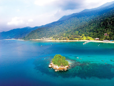
| Aerial view of Tioman: Notice the different hue signifying the depths and objects underneath |
 |
| The colour of the sea holds secrets to what is beneath the water, in the water, on the water and light |
Because of the reflection (and refraction) of light on the surface, sea water changes shade with depth. When approaching a land mass from open ocean, you will transition from dark blue to lighter shades of blue to turquoise to green and then white (for sandy bottoms). This knowledge is useful when looking for a place to anchor or while navigating our way out of a bay full of reefs and rocks. Be careful as dark patches in turquoise waters normally mean rocks or corals.
"When approaching a land mass from open ocean, you will transition from dark blue to lighter shades of blue to turquoise to green and then white (for sandy bottoms)"
The ocean looks blue because red, orange and yellow (long wavelength light) are absorbed more strongly by water than is blue (short wavelength light). So when white light from the sun enters the ocean, it is mostly the blue that gets returned. Same reason the sky is blue.
Tides
"Time and tide will wait for no man"A good navigator must always know what the tide is doing, coming or going at any time. Tides are caused by the gravitational pull of the moon therefore in an unencumbered space like open oceans, the timing of the tide corresponds to the exact location of the moon in the sky. High tide is when the moon is directly overhead. However closer to shores and in places where movement of sea water is hindered by surface contours, there is a lag i.e time difference between the tides and the moon.
Places like Straits of Melaka until Kuantan have two daily tides (semi-diurnal) while those on northern east coast of the Peninsular and Sabah Sarawak have one daily tide cycle (diurnal). For places with semi-diurnal tides, the tide will rise for 6 hours to reach high tide and then it will fall for six hours to reach low tide. The cycle continues.
 |
| Tide table for Tekek showing times and height of High and Low Water |
 |
| Alright guys, put the kettle on. Time for a cigar! or two. |
 |
| Spring Tide, otherwise known as air pasang besar happens twice a month. |
Waves (Ombak) and Swell (Alun)
It is an easy mistake to say that waves set items adrift at sea. Tides move vertically up and down, while currents move water horizontally left or right. What are waves then? Or for that matter what are swells?
"Angin takde dah, ombak pun kurang tapi alun masih kuat"
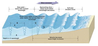
A wave is generally caused by wind or earthquakes undersea. It transfers energy across a body of water. Think of it like shaking out a bedsheet. You can see the waves moving through it but the bedsheet remains in our hands.
The difference between a wave and a swell is a matter of magnitude and not so much scientific. A wave can be born and die within three or four hours. A wave might have travelled tens of kilometres. The crest between waves is somewhere less than 10 seconds. A swell can last a week or so and the crest between swells is more than 10 seconds. A swell can travel hundred of kilometres, even outrunning the storm that gave birth to it. Thus a swell is a good indicator of bad weather to follow.
 |
| Crests and Trough on a wave. General rule of thumb is anything beyond 10 seconds between trough should be considered a swell |
 |
| There are places like the Bay of Biscay where seasoned sailors prefer to sail further outside the continental shelf to avoid rough conditions inshore |
In 1773 Captain Cook sailed close to the treacherous area in the Pacific Ocean called the Tuamoto Archipelago nicknamed the 'Dangerous Archipelago' as too many ships have smashed into the scattered reefs. Although he could not see them, he 'felt' their presence. He was not psychic. The swell that he was expecting from the south, waves that would have been easily felt was absent. He therefore knew that the archipelago must have been in the south and shielding him from the waters!
 |
| The same ripple pattern is true for islands in the oceans. See if you can spot it next time you are out at sea. |