The weather in the UK revolves around movements of cold and warm fronts, and the location of high and low pressure systems. These frontal systems stretch for thousands of kilometres and are easy to spot and can be predicted days in advance. In comparison, the main weather bearing system in the Tropics which is thunderstorm is small and only a few kilometres across. This makes it really difficult to predict the weather. It comes and goes literally in the blink of an eye.
Rather than make this post a purely academic exercise let me make it a bit more practical. I'll try to get you through the basics. And if you are lucky enough, you might just be able to use this knowledge to see what is so blindingly obvious.
1. Know your Monsoons.
 |
| Screen grab from windfinder.com on 4 Dec 2019 showing North East Monsoon in full force |
Always remember, at a particular time of the year, the prevailing winds high above the sky of Malaysia comes from one of two directions:
a) The South West between April - August (summer in the northern hemisphere)
b) The North East monsoon between December - March (winter in the northern hemisphere)
Without going into details, the temperature and pressure gradient between the great Asian land mass and the oceans creates the required conditions for these wind directions.
2. Know the basics about barometric (air) pressure.
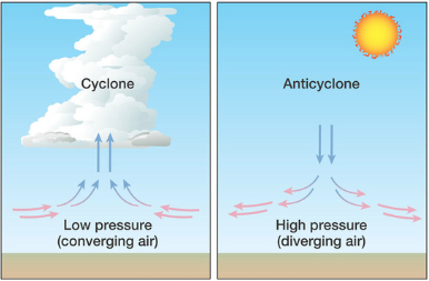
a) Weather in a high pressure system is stable. Surface wind diverges into different directions. Not much precipitation. Small and low cumulous clouds. No rain
b) Weather in a low pressure system is unstable. Wind converges. Towering dark clouds. Potential rain.
Surface winds like the monsoons are the result of air travelling from high pressure region to low pressure region.
3. Understand sea and land breeze.
These makes up the localized wind (as opposed to pressure driven surface winds.

a) During nighttime, land gets cooler more quickly than the sea. Hot air at sea rises, creates a vacuum that is filled by the air from the surface of land. This creates an offshore air movement called land breeze. Coastal fishermen use this knowledge to find the opportune moment to push off to sea.
b) During the day, land gets hotter more quickly than sea. Hot air on land rises, creates a vacuum that is filled by air from the surface of the sea. This creates an inshore air movement called sea breeze. This is when the coastal fishermen come back to land.
4. Know the local conditions.
The list is by no means complete. Go ahead and make your own list:
a) Clouds: It is normal to see a high concentration of cumulous clouds in the mornings. It doesn't mean that rain is coming. Most of these clouds will dissipate in the afternoons and only stratus clouds will remain in the evenings.
 |
| The different types of clouds. The rain producing ones are cross layered i.e. ones that span low and medium levels or middle and top levels. |
b) Local winds can come from a different direction from the prevailing winds from item (1). Its highly influenced by local variables such as land contours and landmarks.
In places like Tioman in the east coast of Peninsular Malaysia surface winds are always present and coming from the South. In the west coast of Peninsular Malaysia surface winds in general comes from the West. When the surface winds clashes with prevailing winds, the weather will deteriorate and you will probably face rain.

c) The main local weather system in Malaysia is the thunderstorm. Recognise this cloud pattern and you get to avoid the chaos caused by thunderstorms. Cue: Look out for the anvil shaped cloud. Rain. That is key to know how far away the storm is and how long it will last. But the first thing you will notice would be the strong winds 10-15 minutes before the arrival of the rain. This is called the downdraft.
d) Observe cues from birds. High flying birds in general shows a high pressure system. No rain.
Whereas, low flying birds show low pressure systems and unstable weather. There might be rain. Notice that when rain is approaching birds fly erratically to get out of the way of rain. Small birds generally disappear when it rains.
e) High humidity in the air is a sign that rain is coming. You can feel the slight heaviness in your breathing and the un-evaporating sweat that collects on your skin. In heavy vegetation areas, you can almost smell the moistness raising from the soil. Its a sign that the air is full of moisture and will rain.
f) Observe the colors in the sky. Rainbows are a sign that the sun is shining on humid air behind the rainbow (see picture), where it is probably raining. Red skies mean unobstructed sunlight and no clouds. Combined this with your knowledge of prevailing winds, you have a good chance of predicting the weather after sunset or after sunrise. For example, a bright red morning sky means clear skies in the East. During the North East monsoon (when prevailing winds come from an easterly direction), this should mean clear skies in the morning and no rain.
 |
| If you are looking for a leprechaun with a pot of gold, this might not be it. |
g) The color of the deep sea water. This was shared with me by a fisherman from Kuala Perlis. Dark clouds at sea does not mean much unless matched by unusually dark sea water underneath it. Rain. Hmm...
 |
| Dark Clouds over Tioman on 10 Nov 2019f. In case you are wondering, it did not rain afterwards. |
I hope the article above has sparked your interest in the weather around us. Try it out. See if you can spot the signs.
Side note:
 |
| The tempua's nest is never low |
Incidentally, I have come across a some of these observations in old Malay literature. I am still compiling these.
Some of the observations are straightforward, like the telling of weather based on cloud shapes during sunrise and sunsets, or how the winds will change according to the observations of the rainbow. But some would require further studies or interpretations such as the meanings of animal shaped clouds in predicting winds. One thing for sure is, the Malays have always been observant of their surroundings.
There is a saying in Malay that goes "Jikalau tidak berada ada, masakan tempua bersarang rendah" meaning, "Beware, when the tempua (bird) makes low nests". Since the tempua normally makes nests in high places, its change in behiviour signals a change in the elements.