Malay Pantun

Tenun Kain Dengannya Kapas
Warna Corak Bermacam Ragi
Perahu Lilin Layar Kertas
Cuba Melanggar Lautan Api

Thursday, 5 December 2019

Signs: How to read the weather

When I came back from the UK, I had to quickly unlearn most of the weather reading skills I had picked up over the years.

The weather in the UK revolves around movements of cold and warm fronts, and the location of high and low pressure systems. These frontal systems stretch for thousands of kilometres and are easy to spot and can be predicted days in advance. In comparison, the main weather bearing system in the Tropics which is thunderstorm is small and only a few kilometres across. This makes it really difficult to predict the weather. It comes and goes literally in the blink of an eye.

Rather than make this post a purely academic exercise let me make it a bit more practical. I'll try to get you through the basics. And if you are lucky enough, you might just be able to use this knowledge to see what is so blindingly obvious.

1. Know your Monsoons.

Screen grab from windfinder.com on 4 Dec 2019 showing North East Monsoon in full force

Always remember, at a particular time of the year, the prevailing winds high above the sky of Malaysia comes from one of two directions:

a) The South West between April - August (summer in the northern hemisphere)

b) The North East monsoon between December - March (winter in the northern hemisphere)

Without going into details, the temperature and pressure gradient between the great Asian land mass and the oceans creates the required conditions for these wind directions.

2. Know the basics about barometric (air) pressure.


a) Weather in a high pressure system is stable. Surface wind diverges into different directions. Not much precipitation. Small and low cumulous clouds. No rain
b) Weather in a low pressure system is unstable. Wind converges. Towering dark clouds. Potential rain.

Surface winds like the monsoons are the result of air travelling from high pressure region to low pressure region.

3. Understand sea and land breeze. 
These makes up the localized wind (as opposed to pressure driven surface winds.


a) During nighttime, land gets cooler more quickly than the sea. Hot air at sea rises, creates a vacuum that is filled by the air from the surface of land. This creates an offshore air movement called land breeze. Coastal fishermen use this knowledge to find the opportune moment to push off to sea.

b) During the day, land gets hotter more quickly than sea. Hot air on land rises, creates a vacuum that is filled by air from the surface of the sea. This creates an inshore air movement called sea breeze. This is when the coastal fishermen come back to land.

4. Know the local conditions. 

The list is by no means complete. Go ahead and make your own list:

a) Clouds: It is normal to see a high concentration of cumulous clouds in the mornings. It doesn't mean that rain is coming. Most of these clouds will dissipate in the afternoons and only stratus clouds will remain in the evenings.

The different types of clouds. The rain producing ones are cross layered i.e. ones that span low and medium levels or middle and top levels.

b) Local winds can come from a different direction from the prevailing winds from item (1). Its highly influenced by local variables such as land contours and landmarks.

In places like Tioman in the east coast of Peninsular Malaysia surface winds are always present and coming from the South. In the west coast of Peninsular Malaysia surface winds in general comes from the West. When the surface winds clashes with prevailing winds, the weather will deteriorate and you will probably face rain.


c) The main local weather system in Malaysia is the thunderstorm. Recognise this cloud pattern and you get to avoid the chaos caused by thunderstorms. Cue: Look out for the anvil shaped cloud. Rain. That is key to know how far away the storm is and how long it will last. But the first thing you will notice would be the strong winds 10-15 minutes before the arrival of the rain. This is called the downdraft.

d) Observe cues from birds. High flying birds in general shows a high pressure system. No rain.
Whereas, low flying birds show low pressure systems and unstable weather. There might be rain. Notice that when rain is approaching birds fly erratically to get out of the way of rain. Small birds generally disappear when it rains.

e) High humidity in the air is a sign that rain is coming. You can feel the slight heaviness in your breathing and the un-evaporating sweat that collects on your skin. In heavy vegetation areas, you can almost smell the moistness raising from the soil. Its a sign that the air is full of moisture and will rain.

f) Observe the colors in the sky. Rainbows are a sign that the sun is shining on humid air behind the rainbow (see picture), where it is probably raining. Red skies mean unobstructed sunlight and no clouds. Combined this with your knowledge of prevailing winds, you have a good chance of predicting the weather after sunset or after sunrise. For example, a bright red morning sky means clear skies in the East. During the North East monsoon (when prevailing winds come from an easterly direction), this should mean clear skies in the morning and no rain.

If you are looking for a leprechaun with a pot of gold, this might not be it.


g) The color of the deep sea water. This was shared with me by a fisherman from Kuala Perlis. Dark clouds at sea does not mean much unless matched by unusually dark sea water underneath it. Rain. Hmm...
Dark Clouds over Tioman on 10 Nov 2019f. In case you are wondering, it did not rain afterwards.


I hope the article above has sparked your interest in the weather around us. Try it out. See if you can spot the signs.

Side note:

The tempua's nest is never low

Incidentally, I have come across a some of these observations in old Malay literature. I am still compiling these.

Some of the observations are straightforward, like the telling of weather based on cloud shapes during sunrise and sunsets, or how the winds will change according to the observations of the rainbow. But some would require further studies or interpretations such as the meanings of animal shaped clouds in predicting winds. One thing for sure is, the Malays have always been observant of their surroundings.

There is a saying in Malay that goes "Jikalau tidak berada ada, masakan tempua bersarang rendah" meaning, "Beware, when the tempua (bird) makes low nests". Since the tempua normally makes nests in high places, its change in behiviour signals a change in the elements.


Thursday, 5 September 2019

Never trust the moorings in Tioman

After a whole day of frolicking at Tulai Bay, the girls, Asyrani and myself left it at sunset only to face a storm coming from the West-Southwest direction.

By the time we reached Tioman shores it was close to 9pm. We followed the shoreline westwards and once we got to the Cabana chalets we started looking for mooring spots. Three boats were already tied to the mooring buoys (or anchored) nearby. It was dark but we managed to find a bouy closest to the shore. Since it was already low tide and we had the required height clearance, there was no worry that we would be grounded. As soon as we could tidy up Relax-Lah from the mess created in the cabin and cockpit by the storm, we rowed to shore in the inflatable. It took us about 10 minutes before the inflatable touched bottom on the sandy beach.
Textbook Approach to a Mooring Bouy

We had dinner at the Cabana cantina overlooking the Bay with the facade of Relax-Lah in the background, recognisable by the anchor lights we left on-board. Weary of the day's adventure, we retired to our chalets close to midnight.

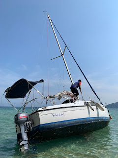
I woke up close to 7am for my morning prayers. Looked out the window of my chalet and there she was, Relax-Lah basking in the sunrise looking as glorious as ever. The tide was coming in. As there was still some time before breakfast, I went back to sleep. I woke up at 9am, looked out the same window lo and behold, there was no Relax-Lah!

I did a quick scan of the horizon and could not see her. Inexplicably, I made my way to the Tekek Marina which was a 10-minutes walk away on the north end of the Bay, perhaps hoping that someone was playing a prank and have moved Relax Lah to her parking spot at the marina. Alas, that turned out to be pure wishful thinking. I ran back to Cabana. From the south end of the bay I saw a gleaming white silhouette. As I walked the half mile to get there, the emerging image put my worries to rest. It was the Relax Lay that was laying at the end of the Bay.

The distance Relax Lah drifted was close to a mile

It seemed that the mooring line broke during high water around 9am. The mooring bouy and some part of the mooring line was still attached to the bow cleat on Relax Lah. She then drifted with the outgoing tide. I jumped on board and immediately put the engine into reverse. Nothing.

As it was already close to two hours past high tide when I found her, a quick look underwater showed that the keel was rested on the sand bottom. I let the boom out and hung out by the side. This should make her lean on one side and get her keel off the ground. When I put the engine in reverse, nothing happened.

Due to the receding water level, Relax Lah was now leaning slightly on its port side with its mast pointing towards the sand dunes on the shore side.

At this point I had a few considerations. By my estimation, the tide was already too low to hope for a tow or a push into deeper waters so I was resigned to mounting a rescue operation when the tide comes back in in about 10 hours around 9 pm. My main worry was firstly to prevent her from drifting towards shallower water than she already was. For this I took out the anchor and buried it as far as I could in deeper water. And my second worry was to avoid the mast getting crushed against the sand dunes or rocks on the beach when she lands on her side on the dry beach.

Meanwhile, help started to arrive. Asyrani my nephew came. Some people came from the nearby resort. A couple of inflatables also arrived from nearby anchored sailboats. Then two boats came from Cabana resort. It was decided to proceed with the tow.

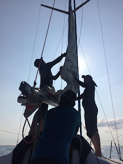
The Odin crew's task was to tilt the boat by keeping tension on the halyard tied to the mast
Two lines attached to the port and starboard bow cleats were thrown to the two Cabana boats. At the same time the halyard on the mast was handed to the inflatable from Odin to keep the boat heeling to the side as much as she could to lift the keel from the sand. The rest of the people exerted their weights on the port side of the boat, to aid the heeling. Slowly but surely, Relax Lah started to break free. It took a good 15 minutes and a few bumps on the rocks and she was free.

The two Cabana boats pulled on the tow lines


This success overwhelmed me. I was and will forever be grateful that Relax Lah did not end up on the rocks or worse as a ghost ship floating somewhere between Tioman and China. I was touched by the unexpected help I got from all these strangers.

As always, there are lessons to be learned from this experience. The main one being never trust the moorings in Tioman!


Monday, 13 May 2019

Aur and Beyond

There is not that many places you can visit that boast to be the farthest* island from mainland peninsular Malaysia.


The route we took captured by the GPS

This trip brought Relax Lah and its crew to two of the most spectacular islands we have seen yet in the Tioman archipelago.  Pulau Aur is located 45 nautical miles Southeast of Tioman. Pulau Pemanggil lies midway between these two bigger islands.
 We left Tekek Marina, Tioman right after fajr on Sunday with the ebbing tide.  This gave us the opportunity to watch the spectacular sunrise over the eastern horizon as we left the Southern tip of Tioman. The Northeastern monsoon seemed to have died down and we motor-sailed with the aid of the Southerly-Southeastern wind.

We were helped by South-Southeastern winds


We reached  Kandor Bay on the east side of Pemanggil around noon. Since the settlements and resorts on Pemanggil are located in the West and Southwest side, we had the whole Eastern side to ourselves.


Some of the crew badly needed a refresher course on inflatable rowing


The sandbank in the middle of the Bay plus the gradual slope of the beach made it a challenge to anchor close to the beach. We secured Relax Lah at a mooring buoy further out in the South side of the Bay.
Then we took the inflatable and found a landing spot. The narrow beach was littered with huge granite rocks, some forming natural shelter. These rocks can be seen all the way up the hilly Eastern slope of Pemanggil.


We made camp and spent the afternoon snorkelling and enjoying the food we brought. At low tide we hiked up the rock ridden hills to explore the other side of the bay. We didn't get far. The hills are too steep and the rocks unaccessible, for us at least. Sunset saw us around the campfire.


After lunch siesta
Sunset by the campfire
Free diving at the wreck at Telok Kandor, Pemanggil
The next morning we explored a pre WW1 wreck* north side of the bay. At low water, the wreck was under less than 5m of water. This made it possible for us to explore it just by snorkelling and free diving.


The initial approach is shown here by the red arrow. X mark the spots that the engine died and had to be re-started. Yellow arrow shows the alternate route taken.

Batu Berhala, lords over the entrance to Dayang Straits
We left Pemanggil that morning and continued Southeast. By noon we reached Aur. From Pemanggil, the approach to the Jetty at the main village on Pulau Aur is straight line through the gap between Pulau Dayang and Pulau Lang. Batu Berhala, that sits on top of the Aur village looks over this gap like a hawk. We tried this route two times. In both instances the engine turned off when we reached the middle of the gap. It seemed that at that particular moment during the rising tide, water was flowing from the North of the Dayang channel southwards. Strong current was coming thru the gap Dayang-Lang gap and caused my  15hp engine to stall. In the third attempt, we rounded pulau Lang and came thru the back.


What awaited us at Aur
We spent the afternoon frolicking on Pulau Aur. Got lunch, had a good swim, got our supply of kretek cigarettes and before sundown we were on our way back to Tekek.


Island? What island? I don't see any island.

Footnote:

1. The distance between Pulau Aur and Pulau Jemaja in the Indonesian Anambas archipelago is 80 nautical miles. Interestingly, Indonesia staked a claim to Pulau Jemaju and the Anambas Islands only in 1956. Prior to that, it is documented that Jemaja had close relations to the British and the Johor Sultanate.

2. Nothing much was documented regarding the wreck. Some say the ship en route to Thailand with its cargo of maize and tamarind smashed onto the rocks in Kandor Bay and sank instantlyin 1966. Some say it is a pre-WW1 wreck.

3. Aur and Pemanggil have always been a stop over place for weary fishermen and merchant sailors. There are stories about these islands being used as a pirates' den. These are evident in the wrecks found in the waters off Pemanggil and Aur. It is also documented that the waters off Aur was witness to the encounter between the British East India fleet with the French Napoleonic fleet in Feb 1804.


Sunday, 3 March 2019

Sticky Boat Bottoms

Last weekend, after a hiatus of five months we saw Relax Lah again. This was not the first time we left Relax Lah at the mercy of the elements in Tioman during the monsson season. Its the second. Things happen when you leave a boat. Parts come off, batteries go flat, decks get mouldy, engines stall, metals get rusty, plastics and wood get brittle and peel offs. A glance at the rudder and a quick dip underneath the boat showed a layer of shells and barnacles that need to be scrapped off. In addition to reducing the drag on the boat speed caused by them, it also avoids permanent damage on the body of the boat.


It has been two years that I moved the boat from Sebana Cove to Tioman. The difference between these two places is Sebana Cove is located upstream of the freshwater River Sebina whereas Tioman sits in the middle of the South China Seas. Its common knowledge that barnacles natural habitat is in saltwater and have a snowball's chance in hell to survive in fresh water.

Rahman got the ball rolling by clearing the rudder and the sides just beneath the waterline. Armed with a life vest and scraper, it took him a good part of Saturday afternoon to clear these areas of barnacles and shells.


Myself, I was trying to clear areas underneath the hull and the keel. Took my vest off and did a free dive down to have a look. The hull was relatively clear of growth, compared to to the rudder. But the keel was almost covered, especially the posterior surface. In order to chip away at the growth, I had to take a deep breath, jump in, take a few stabs at either at scraping or hammering at the buildup and come up to the surface for air. All these happened in a space of one and a half minutes. After doing this for what seems like an eternity and with little to show for it, I decided that this wasn't going to work.


Next day, I started afresh by renting a set of scuba diving equipment. That gave me a good hour underwater to complete the task (almost).

So here it is, a low down on barnacles and shells found in Malaysia and underneath Relax Lah!

Basically, there are three organisms that are found on hard surfaces. These are often mistaken for each other although they have distinct characteristics.


Barnacles
Teritip (Malay)

Barnacles don't move once they settle down as a tiny larvae on their chosen surface.
There is a hole at the top of the hard shell.
At low tide, the hole at the top of the shell is tightly closed by a pair of plates to reduce water loss


Limpets
Berangas (Malay)

Limpets can move around on their broad foot.
Some limpets have holes at the top of the hard shell, others do not. The hole is not closed by plates.
At low tide, they usually tightly clamp down against the surface and are difficult to dislodge.


Oysters
Tiram (Malay)

Oysters don't move once they settle down as a tiny larvae on their chosen surface.
Oysters have a two-part shell (i.e., two valves) like other clams. One valve is stuck to the rock. There is a gap between the valves.
At low tide, the valves are tightly shut to reduce water loss.


Tuesday, 1 January 2019

Tioman in History Books

There is this inexplicable awe that overcomes me every single time Tioman comes on the horizon. Be it in the window of the turbo prop plane decades ago, on the deck of the ferry or the bow Relax lah in my recent trips, I always feel that this majestic island in the middle of a great ocean has a story to tell. A story about all the ships that has passed by, their rich cargo and weary crew.

Maritime routes in southeast asia has not changed much with time

Located in the middle of the trade route in between China, Ryuku (Okinawa), Vietnam, Siam, Patani on one side and the Malay archipelago and west Asia on the other side, Tioman offers perfect shelter from the annual northeast monsoon winds and rain. In addition, it provides a stopover for weary sailors and a sure supply of water and wood essential for a boat after long voyages at sea.

Map showing location of Nipah, possiblly one of the earlier settlement on Tioman where significant ceramic find were made
The earliest recorded reference to the island is in the Arabic text "Akbar Al Sind Wal Hind" written sometime around 1000 AD that mentions "Then the ship travelled to a place called Betumah (Tioman) which has fresh water for anyone who desires it".

Early Chinese traders, who had a long history of trade with Nanhai, the term they used to denote the Southern Seas were also familiar with the island. In fact, Tioman was mentioned in Chinese 15th century charts used during the voyage of Admiral Zheng He, whose travel started from Beijing and reached as far West as Zanzibar and Mecca.

Ceramics collected in Nipah Bay have been identified to have origins in Korea, Sri Lanka and the coasts of Africa and America proving indeed that Tioman was for centuries actively involved in the maritime trade of Asia.


In the earliest charts published by western cartographers, Tioman appears prominently in names as such as Timao.

Chart made by Cornelius Claesz in 1595 showing Tioman (Timao) and its surrounding islands
When the Portuguese occupied Malacca in 1511, the Estado da India established a post on Tioman to look after movements of their trading vessels between Malacca and the other Portuguese colony in Macau. In a twist of irony, when the  Dutch East India company wanted to disrupt trade of Estado da India, their Portuguese rival during the decline of the latter the used Tioman as a spying post where a roaming squadron of warships would monitor trade movements between the mainland and the Malay peninsular and loot them.

Dutch phamphlet depicting the seize of Portuguese carrack Santa Catarina off Johore by Admiral Jacob Van Heemskerk who was laying in wait with his attack squadron in Tioman


In Feb 1603 Santa Catarina a Portuguese carrack loaded with riches from China, Ryuku and Macau was seized at the mouth of Johor River near nowaday Tanjung Pengelih. The Dutch squadron which intercepted Santa Catarina had been on watch a few days before in Tioman when a messenger came from Raja Kecil of Johor Lama informing them of the presence of Santa Catarina in the area.

In more recent history, Tioman and all islands to the south of it was presented by Tun Tahir of Pahang to the Temenggong of Johor for his support in the then ongoing civil war with his brother Tun Ahmad in 1862. However, in 1863, when Tun Ahmad later triumphed and became the Bendahara of Pahang, he refused to recognise this cessation. Only in 1866 Temenggong Abu Bakar of Johore agreed to cede Tioman and Seri Buat back to Pahang but the border dispute continued until 1897 when it was decided that the left bank of the Endau river belongs to Pahang and all islands north of a line drawn east from the Endau River belong to Pahang and anything in the south belong to Johore.


Tioman also saw early action in World War 2. When the Japanese landed in Songkla (Singora) Thailand on Dec 8, 1941 and continued to march south, one of the first response by the British Army was to send Force Z consisting HMS Prince of Wales and battlecruiser HMS Repulse and four destroyers. These were intercepted by Japanese bombers and both ships were sunk on Dec 10, 1941 not far from Tioman with a total loss of 840 people.