Malay Pantun

Tenun Kain Dengannya Kapas
Warna Corak Bermacam Ragi
Perahu Lilin Layar Kertas
Cuba Melanggar Lautan Api

Sunday, 31 January 2021

Anchorages in the Tioman & Mersing Group of Islands

Anchorages around the Islands


Relax Lah! anchored off Pulau Harimau. P.Rawa in the distant background

I guess it's about time that this blog entry is created. Considering Relax Lah and crew spend a reasonable amount of time around the islands Tioman, it is incumbent upon us to document anchorages in the area and approaches to them. If not us who else, right?

Although in reality there is no division, for our purpose lets divide these islands into two groups, the Tioman Group and the Pulau Tinggi group.

Tioman
The island has provided shelter to weary travellers for a millenium. No matter the direction of wind and swell, Tioman provides protection. There are three main anchor spots, around Tekek Bay, Juara Bay in the East and Mukut Bay in the South.

Relax Lah experience: This is our home base. Although we have a permanent place in the Marina, we have had occasions where we had to anchor out. Marina rennovations, or a day out snorkeling or late nights coming back from distance islands when the marina was full are some of the reasons for these.

# Description         Holding         Lat                 Long
1 Tekek Bay Anc Sand/Rocks 2°49.113N 104°9.397E
2 Mukut Bay Anc Sand/Rocks 2°43.129N 104°11.688E
3 Juara Bay Anc Sand/Rocks 2°47.39N 104°12.22E
4 Pulau Tulai  West Sand/Rocks 2.9083735 N 104.1087659 E


Relax Lah! anchored off Tekek Bay, Tioman. Cabana Lodgings in the background

Crew jumping off the bow at P.Tulai anchorage


P.Seri Buat & P.Sembilang
These twin sisters are the closest islands West of Tioman. The gap in between them reach drying heights at low tide, and not passable on a boat. North and South of the channel it is possible to anchor in sand at a depth of around 10 meters before the deep drop offs. There is also a mangrove river that can be explored on a dingy in Pulau Sembilang.

Relax Lah experience: We have anchored and moored around Seri Buat a couple of times. We found that around these islands, the wind and swell come from different directions than we were expecting. On our first trip there en route from Tioman to Rawa during the south west season, we had anchored on the North side of the channel only to find out that the swell was from the north and we were not in the best spot to spend the night. Against our plans, we had to round the island to find a good protected spot in the South. 

# Description                         Holding Depth Lat                 Long
1 Seri Buat, South of Channel Sand 5-10m 2°40.785N 103°53.962E
2 Seri Buat, North of Channel Reef 10-12m 2°41.831N 103°53.913E
3 South of Sembilang         Sand 10-12m 2.6797927N 103.9040423E


Relax Lah! crew mending engine frame off Seri Buat


Pulau Rawa
Because the orientation of the island runs diagonal Northwest to Southeast, the countour does not shield boats from the Southerly or the Northeasterly, the two most common prevailing winds in the area. However, some mooring bouys are made available by the Rawa Island Resort for use by guests.

Relax Lah experience:
We visited Pulau Rawa twice and on both occasions took up the mooring bouy northeast of the Pulau Rawa Resort Jetty.

# Description                 Holding Depth Lat                 Long
1 Rawa Anc/Mooring Sand 8-10m 2°31.005N 103°58.492E


Mooring off P.Rawa for some R&R


Pulau (Babi) Besar, Tengah dan Hujung

Only P. Tengah and P. Besar has resorts and these are easily spotted around the jetties.  You can see lights from the shores of Mersing from here. These string of islands are also a close hop from Pulau Rawa. The two north islands are connected by shallow reefs with a clearence less than 5m.

Relax Lah experience: Unable to find a suitable place to anchor near Rawa when we need protection from the wind and swell from the south, we rounded pulau Tengah and found a relatively calm spot between Tengah and Kecil to anchor overnight. The next day we picked up anchor and headed south to Besar. We found mooring bouys near the jetty, but with the impending storm decided to set anchor as a back-up.

# Description         Holding Depth Lat                 Long
1 P.Besar West Anc Sand 10m         2°25.855N 1    03°58.494E
2 P.Tengah Sand                 3-6         2°28.402N 103° 57.377E


Pulau Tinggi: 

A 12 n miles hop from P Besar, Pulau Tinggi has been described as the triangle island because of the façade from afar. It is popular among divers and fishing folks. Two main anchorage areas. First in the south east part of the island between P. Tinggi and P. Simbang. The second spot in the south west of the coral reef in front of the beach – beautiful but only safe during quiet weather. 

Relax Lah experience: We have not reached P. Tinggi yet!

# Description                 Holding Depth Lat                 Long
1 P. Tinggi North Anc Sand 11m         02° 19'.0 N 104° 06'.0 E
2 P.Tinggi SE Anc 10-15m                 Between P. Tinggi & Simbang
3 P.Tinggi SW Anc                         West of Coral reef by the beach


Pulau Sibu: 

Being the most southerly island in the Mersing group, this island is popular among Singaporeans.There are restaurants and bars along the two long beaches in the east of the island. Possible to anchor in 12 m on a sand bottom, but be careful to not go to close to shore as a large band of coral is lying close to the beach.The south part of the island and P. Sibu Tengah are not accessible by sailing boat as it is full of coral patch. 

Relax Lah experience: We have not reached Sibu yet!

# Description         Holding     Depth     Lat         Long
1 P.Sibu East Anc Sand     6m     02°13.3 104°04.3
2 P.Sibu West Anc Sand/Mud    4m     02°12.86 104°03.66  


Pulau Pemanggil

Visible on the southeast horizion of P.Tioman is P.Pemanggil. Resorts and village on the north coast and the southern side is quite isolated. Only on Pemanggil one get to snorkel a wreck in 5 meters of water on low tide. 

Relax Lah experience:
We passed by Pemanggil a couple of times, but anchored here only once. The isoloation of Telok Kandar is exquisite. After a few tries, we found a place to anchor in the sandy bay. Spent a good part of the afternoon climbing rocks on the cliff. The secluded by provided good protection from wind and tide overnight. Next morning we took our time to explore the wreck.

# Description                         Holding     Depth         Lat             Long
1 Telok Kandar Anchoring                 2.5788035    104.3291795
2 North Pemanggil Anchoring                                2.5828009    104.3210064 


Crew heading towards P.Pemanggil Teluk Kandar    

Pulau Aur

Approach from the west, either side of Pulau Lang, to anchor in 8-16 metres anywhere in the channel. This is the regional overnight spot providing good protection from north and south swells. The tidal flow through the channel can run up to two knots on springs. Fishing boats often raft-up in heavy weather. There are resorts on both side of the channel between Pulau Dayang and Pulau Aur. There are mooring bouys to be picked up near the village jetty. 

Relax Lah experience: The 15hp outboard struggled with the strength of the current in the channel. It died two times. We took up a mooring bouy near the village. In hindsight, we should have set up anchor as added security. 

# Description             Holding Depth     Lat         Long
1 Bet P.Aur & P.Dayang                          2°28.11N 104°30.13E
2 P.Aur East Anc                             2°27.690N 103°31.643E


P. Aur pix taken from the Jetty. Relax Lah! took up a mooring bouy.


Distance table


Thursday, 16 April 2020

Signs: How to read the sea

We all love looking out to the sea. There is something majestic, calming and hypnotic about the sight of breaking waves and floating ships. The sea holds secrets and if we look closely these secrets are revealed. For a navigator, the sea provides signs that can make a difference between sinking and surviving, between setting adrift and finding land.

Colour of water
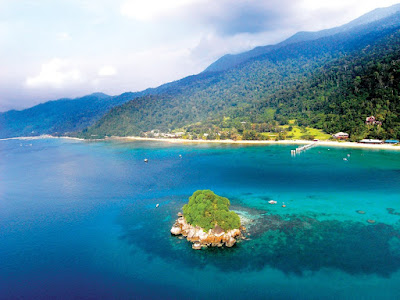
Aerial view of Tioman: Notice the different hue signifying the depths and objects underneath
There are four main factors that determine the colour of the seawater we see, mainly what is beneath the water, what is in the water, what is on the water and the effects of light. Since I write this article primarily for looking out signs to help navigation, I will focus on the shade of water for now. Items like salt, mud, salinity, particle and organism content will be discussed in a separate forum.

The colour of the sea holds secrets to what is beneath the water, in the water, on the water and light

Because of the reflection (and refraction) of light on the surface, sea water changes shade with depth. When approaching a land mass from open ocean, you will transition from dark blue to lighter shades of blue to turquoise to green and then white (for sandy bottoms). This knowledge is useful when looking for a place to anchor or while navigating our way out of a bay full of reefs and rocks. Be careful as dark patches in turquoise waters normally mean rocks or corals.

"When approaching a land mass from open ocean, you will transition from dark blue to lighter shades of blue to turquoise to green and then white (for sandy bottoms)"

 The ocean looks blue because red, orange and yellow (long wavelength light) are absorbed more strongly by water than is blue (short wavelength light). So when white light from the sun enters the ocean, it is mostly the blue that gets returned. Same reason the sky is blue.


Tides
"Time and tide will wait for no man"
A good navigator must always know what the tide is doing, coming or going at any time. Tides are caused by the gravitational pull of the moon therefore in an unencumbered space like open oceans, the timing of the tide corresponds to the exact location of the moon in the sky. High tide is when the moon is directly overhead. However closer to shores and in places where movement of sea water is hindered by surface contours, there is a lag i.e time difference between the tides and the moon.


Places like Straits of Melaka until Kuantan have two daily tides (semi-diurnal) while those on northern east coast of the Peninsular and Sabah Sarawak have one daily tide cycle (diurnal).  For places with semi-diurnal tides, the tide will rise for 6 hours to reach high tide and then it will fall for six hours to reach low tide. The cycle continues.


Tide table for Tekek showing times and height of High and Low Water


On a personal note, this information was crucial when I found myself grounded on sandbanks off Beaulieu River or Tulai. Lets say I touched bottom as the tide was leaving three hours before low tide. This means that I will need to wait three hours for the tide to leave until it reaches low tide and then another three hours for it to get back to the level I was stranded at. Then maybe add one or two hours when the boat will release itself from the bottom.

Alright guys, put the kettle on. Time for a cigar! or two.
Note: Tide times shift by an additional 50 minutes a day since they are based on a lunar day, which is 24 hours 50 minutes long.

Spring Tide, otherwise known as air pasang besar happens twice a month.
The difference in height between the sea level at high tides and at low tides is called the tidal range. It can go up to 3.6 meters near Matang, Perak among the highest in the Peninsular.  Twice a month, during a new moon and a full moon, the tidal range is at its maximum for all places. This is when the high tides is its highest and the low tide is its lowest. This is called the spring tide in English, or air pasang besar in Malay. Combined with the monsoon rain, this is normally when flash floods happen in the East Coast.

Waves (Ombak) and Swell (Alun)
It is an easy mistake to say that waves set items adrift at sea. Tides move vertically up and down, while currents move water horizontally left or right. What are waves then? Or for that matter what are swells?

"Angin takde dah, ombak pun kurang tapi alun masih kuat"

A wave is generally caused by wind or earthquakes undersea. It transfers energy across a body of water. Think of it like shaking out a bedsheet. You can see the waves moving through it but the bedsheet remains in our hands.

The difference between a wave and a swell is a matter of magnitude and not so much scientific. A wave can be born and die within three or four hours. A wave might have travelled tens of kilometres. The crest between waves is somewhere less than 10 seconds. A swell can last a week or so and the crest between swells is more than 10 seconds. A swell can travel hundred of kilometres, even outrunning the storm that  gave birth to it. Thus a swell is a good indicator of bad weather to follow.
Crests and Trough on a wave. General rule of thumb is anything beyond 10 seconds between trough should be considered a swell
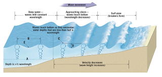
It is also important to note that a wave that is approaching shallow waters will increase its height. Since it is still carrying the same energy, yet it's wavelength is decreased.

There are places like the Bay of Biscay where seasoned sailors prefer to sail further outside the continental shelf to avoid rough conditions inshore

In 1773 Captain Cook sailed close to the treacherous area in the Pacific Ocean called the Tuamoto Archipelago nicknamed the 'Dangerous Archipelago' as too many ships have smashed into the scattered reefs. Although he could not see them, he 'felt' their presence. He was not psychic. The swell that he was expecting from the south, waves that would have been easily felt was absent. He therefore knew that the archipelago must have been in the south and shielding him from the waters!

The same ripple pattern is true for islands in the oceans. See if you can spot it next time you are out at sea.

Saturday, 29 February 2020

Signs: What the night sky tell us

Have you ever had the chance to stare at the night sky in total darkness, when nothing else can be seen?

While it may be the subject of poetry and nice pictures, to a natural navigator it serves as a calendar, a clock, a compass and a map all rolled into one.

Lets start with how we can use the night sky to find direction.

The Moon

You can't really miss the biggest object in the night sky. Every 29 and a half days, the moon goes through its regular cycle.

The different phases of the moon throughout the 29 day cycle

The crescent before the full moon is dark on the left side, while the crescent after the full moon is dark on the right side.

Tip #1 - A line from the horn of a high crescent moon extended to your horizon gives a rough indication of south.
Follow the line from the horn of the crescents down to the horizon and you get the direction of South

A short explaination. From the perspectivce of an observer on the surface of the planet, the sun and the moon travels along the same route on the horizon from east to west.  Imagine a race that starts on the first night of the new moon. Both the sun and the moon starts of at the beginning line on the east horizon at the same time. Since the moon's relative movement is slower than the sun, it lags behind by 12 degrees a day. The bright side of the moon always reflect where the sun is relative to the moon, either on its east or on its west. Hence the line connecting the horn of the crescent with the horizon is always the north-south line.

The Stars and Planets

Tip #2 - Orion sword points south

Stars, planets and constellations come and go from the Malaysian night sky, but Orion remains. Orion is the name of a great hunter in Greek mythology. The constellation (group of stars) look like a hunter holding a club and a shield/bow. Its quite easy to spot. I normally look for a straight row of the three brightest starts closely huddled together. This is called Orion's Belt.

Here's the tip. Extend a line from the tip of Orion's belt all the way to the horizon. Walk towards the point where this line touches the horizon. That will take you south.

Its easiest to spot the three stars in a straight line that make Orion's belt


Tip #3 - Finding Polaris, the North Star

To put it simply, Polaris is uniquely positioned on top of the North Pole. So wherever you are in the world, when you find Polaris the line between Polaris and you points North.  There are a few tricks to find this North Star.

To a natural navigator the night sky serves as a calendar, a clock, a compass and a map all rolled into one
3a. The Big Dipper

For some reason, I find this method the easiest when I was in the UK, but not so in Malaysia. First you need to find something that looks like a dipper (or a senduk in Malay).  Focus on the container and ignore the handle. Identify the two stars that would make liquid spill from the side if you turn the dipper on its handle. In a straight line five portions above will be Polaris. Walk towards the start if you want to go North.
Remember the Dipper, remember North Star


3b. The Cassiopeia

This constellation looks like an asymmetric W.  Imagine across the top of the W. Extend this line two lengths from the star at the middle of the W and you will find the North Star.
Extend a line two lengths of the W from the middle start

Tip #4 - Bintang Timur & Bintang Barat
I sailed overnight once with the son of a fisherman from Kemaman. As we crossed the bit of South China Seas from Sebana Cove to Tioman. He pointed out two the two brightest stars visible in the sky that night, Bintang Timur (East Star) and Bintang Barat (West Star) as the fishermen would call them. As it turns on, these are called Sirius in the east and planet Saturn in the west respectively.

Tuesday, 14 January 2020

Shipwrecks in Malaysia

In his book Empire of the Winds, Phillip Bowring used the term "Nusantara", a term coined by the Java-based Majapahit kingdom to describe the archipelago that stretches from Papua in the East to Madagascar in the west, Java in the south and Taiwan in the north. He considers this corridor as the worlds "greatest maritime and cultural crossroads, a corridor connecting East Asia, the Arab-Persian world, Europe and the African coast".

The Malay Peninsular was part of the East-West network of ports

Because of its strategic location and the good fortune of being at the meeting point of two monsoons,  for about a thousand years the people of the Nusantara were the middle man for trade between the east and west. Their skills in boatbuilding and navigation enabled them to move cargo like silk and porcelain from China and pepper from this region to places like Gujarat and Musiris on the west coast  of India or Madagascar in Africa where the onward journey would take these goods to Rome or Greece. Goods from the West like glass from Rome and pearls from the middle east also reached China on Nusantaran vessels.

With a thousand year history being at the heart of world maritime trade, it is surprising that more shipwrecks have not been found in the waters surrounding Malaysia.

Location of historical wrecks around the Peninsular
Here are some of the things we know about these historical wrecks (defined as ships that sunk more than 100 years ago).


The Malaysian government has formalized the search and harvesting of these artifacts with Nanhai Marine Archeology Sdn Bhd, a private company specializing in historical wrecks.


Here is a video of one of the dives conducted on the 
Wanli wreck from the company's website.


Sukhothai fish and flower plate found on the Nanyang


Sukothai and Satchanalai pottery and cauldrons make up a big chunk of the cargo found

Sukhothai fish and flower plate found on the Nanyang

The wreck at Turiang would have looked like this Chinese Junk

The Royal Nanhai was made of wood native to Southeast Asia combining Chinese and Local shipbuilding technology
Diana was an East India Company tradeship that struck rocks off the coast of Tg Bidara while en route to Madras

The route taken by Diana on that unfortunate night on March 4, 1817
There are still numerous known wrecks that have eluded treasure hunters for decades. For example, in the areas around Cape Ricardo, Port Dickson where a sea battle was fought between the Dutch and Portuguese Armada most of the sunken ships have yet to be be found.

Similarly, in the vicinity of the mouth of Johor River, where Johor Lama once stood there were a lot of sea battles for the control of trade between the French, Dutch, Portuguese and English armada's.

Yet, the biggest catch would be the wreck of Flor De La Mar, the Portuguese Galleon that was used to in the Portuguese conquest of Melaka in 1511. When the city - noted for being one of the richest in the world at that time fell, the booty captured from the fallen kingdom was loaded on to Flor De La Mar to be transported back to Portugal via transit in Goa. According to a contemporary report, it was whilst sailing along the coast of Sumatra that the ship was caught in a storm. An attempt was made to seek refuge on the coast, but the ship was wrecked on a beach. As a result, the ship broke into two, and its back, which was embedded in the sand, demolished by the waves. Along with the ship, the treasure was also lost. 

Flor De La Mar was transporting the war booty taken from Melaka before it sunk in the Straits of Melaka in 1512.
When I sail, I always  wonder what hidden treasures lies beneath the waves.

Thursday, 5 December 2019

Signs: How to read the weather

When I came back from the UK, I had to quickly unlearn most of the weather reading skills I had picked up over the years.

The weather in the UK revolves around movements of cold and warm fronts, and the location of high and low pressure systems. These frontal systems stretch for thousands of kilometres and are easy to spot and can be predicted days in advance. In comparison, the main weather bearing system in the Tropics which is thunderstorm is small and only a few kilometres across. This makes it really difficult to predict the weather. It comes and goes literally in the blink of an eye.

Rather than make this post a purely academic exercise let me make it a bit more practical. I'll try to get you through the basics. And if you are lucky enough, you might just be able to use this knowledge to see what is so blindingly obvious.

1. Know your Monsoons.

Screen grab from windfinder.com on 4 Dec 2019 showing North East Monsoon in full force

Always remember, at a particular time of the year, the prevailing winds high above the sky of Malaysia comes from one of two directions:

a) The South West between April - August (summer in the northern hemisphere)

b) The North East monsoon between December - March (winter in the northern hemisphere)

Without going into details, the temperature and pressure gradient between the great Asian land mass and the oceans creates the required conditions for these wind directions.

2. Know the basics about barometric (air) pressure.


a) Weather in a high pressure system is stable. Surface wind diverges into different directions. Not much precipitation. Small and low cumulous clouds. No rain
b) Weather in a low pressure system is unstable. Wind converges. Towering dark clouds. Potential rain.

Surface winds like the monsoons are the result of air travelling from high pressure region to low pressure region.

3. Understand sea and land breeze. 
These makes up the localized wind (as opposed to pressure driven surface winds.


a) During nighttime, land gets cooler more quickly than the sea. Hot air at sea rises, creates a vacuum that is filled by the air from the surface of land. This creates an offshore air movement called land breeze. Coastal fishermen use this knowledge to find the opportune moment to push off to sea.

b) During the day, land gets hotter more quickly than sea. Hot air on land rises, creates a vacuum that is filled by air from the surface of the sea. This creates an inshore air movement called sea breeze. This is when the coastal fishermen come back to land.

4. Know the local conditions. 

The list is by no means complete. Go ahead and make your own list:

a) Clouds: It is normal to see a high concentration of cumulous clouds in the mornings. It doesn't mean that rain is coming. Most of these clouds will dissipate in the afternoons and only stratus clouds will remain in the evenings.

The different types of clouds. The rain producing ones are cross layered i.e. ones that span low and medium levels or middle and top levels.

b) Local winds can come from a different direction from the prevailing winds from item (1). Its highly influenced by local variables such as land contours and landmarks.

In places like Tioman in the east coast of Peninsular Malaysia surface winds are always present and coming from the South. In the west coast of Peninsular Malaysia surface winds in general comes from the West. When the surface winds clashes with prevailing winds, the weather will deteriorate and you will probably face rain.


c) The main local weather system in Malaysia is the thunderstorm. Recognise this cloud pattern and you get to avoid the chaos caused by thunderstorms. Cue: Look out for the anvil shaped cloud. Rain. That is key to know how far away the storm is and how long it will last. But the first thing you will notice would be the strong winds 10-15 minutes before the arrival of the rain. This is called the downdraft.

d) Observe cues from birds. High flying birds in general shows a high pressure system. No rain.
Whereas, low flying birds show low pressure systems and unstable weather. There might be rain. Notice that when rain is approaching birds fly erratically to get out of the way of rain. Small birds generally disappear when it rains.

e) High humidity in the air is a sign that rain is coming. You can feel the slight heaviness in your breathing and the un-evaporating sweat that collects on your skin. In heavy vegetation areas, you can almost smell the moistness raising from the soil. Its a sign that the air is full of moisture and will rain.

f) Observe the colors in the sky. Rainbows are a sign that the sun is shining on humid air behind the rainbow (see picture), where it is probably raining. Red skies mean unobstructed sunlight and no clouds. Combined this with your knowledge of prevailing winds, you have a good chance of predicting the weather after sunset or after sunrise. For example, a bright red morning sky means clear skies in the East. During the North East monsoon (when prevailing winds come from an easterly direction), this should mean clear skies in the morning and no rain.

If you are looking for a leprechaun with a pot of gold, this might not be it.


g) The color of the deep sea water. This was shared with me by a fisherman from Kuala Perlis. Dark clouds at sea does not mean much unless matched by unusually dark sea water underneath it. Rain. Hmm...
Dark Clouds over Tioman on 10 Nov 2019f. In case you are wondering, it did not rain afterwards.


I hope the article above has sparked your interest in the weather around us. Try it out. See if you can spot the signs.

Side note:

The tempua's nest is never low

Incidentally, I have come across a some of these observations in old Malay literature. I am still compiling these.

Some of the observations are straightforward, like the telling of weather based on cloud shapes during sunrise and sunsets, or how the winds will change according to the observations of the rainbow. But some would require further studies or interpretations such as the meanings of animal shaped clouds in predicting winds. One thing for sure is, the Malays have always been observant of their surroundings.

There is a saying in Malay that goes "Jikalau tidak berada ada, masakan tempua bersarang rendah" meaning, "Beware, when the tempua (bird) makes low nests". Since the tempua normally makes nests in high places, its change in behiviour signals a change in the elements.


Thursday, 5 September 2019

Never trust the moorings in Tioman

After a whole day of frolicking at Tulai Bay, the girls, Asyrani and myself left it at sunset only to face a storm coming from the West-Southwest direction.

By the time we reached Tioman shores it was close to 9pm. We followed the shoreline westwards and once we got to the Cabana chalets we started looking for mooring spots. Three boats were already tied to the mooring buoys (or anchored) nearby. It was dark but we managed to find a bouy closest to the shore. Since it was already low tide and we had the required height clearance, there was no worry that we would be grounded. As soon as we could tidy up Relax-Lah from the mess created in the cabin and cockpit by the storm, we rowed to shore in the inflatable. It took us about 10 minutes before the inflatable touched bottom on the sandy beach.
Textbook Approach to a Mooring Bouy

We had dinner at the Cabana cantina overlooking the Bay with the facade of Relax-Lah in the background, recognisable by the anchor lights we left on-board. Weary of the day's adventure, we retired to our chalets close to midnight.

I woke up close to 7am for my morning prayers. Looked out the window of my chalet and there she was, Relax-Lah basking in the sunrise looking as glorious as ever. The tide was coming in. As there was still some time before breakfast, I went back to sleep. I woke up at 9am, looked out the same window lo and behold, there was no Relax-Lah!

I did a quick scan of the horizon and could not see her. Inexplicably, I made my way to the Tekek Marina which was a 10-minutes walk away on the north end of the Bay, perhaps hoping that someone was playing a prank and have moved Relax Lah to her parking spot at the marina. Alas, that turned out to be pure wishful thinking. I ran back to Cabana. From the south end of the bay I saw a gleaming white silhouette. As I walked the half mile to get there, the emerging image put my worries to rest. It was the Relax Lay that was laying at the end of the Bay.

The distance Relax Lah drifted was close to a mile

It seemed that the mooring line broke during high water around 9am. The mooring bouy and some part of the mooring line was still attached to the bow cleat on Relax Lah. She then drifted with the outgoing tide. I jumped on board and immediately put the engine into reverse. Nothing.

As it was already close to two hours past high tide when I found her, a quick look underwater showed that the keel was rested on the sand bottom. I let the boom out and hung out by the side. This should make her lean on one side and get her keel off the ground. When I put the engine in reverse, nothing happened.

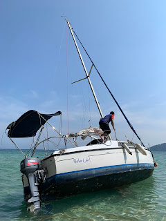
Due to the receding water level, Relax Lah was now leaning slightly on its port side with its mast pointing towards the sand dunes on the shore side.

At this point I had a few considerations. By my estimation, the tide was already too low to hope for a tow or a push into deeper waters so I was resigned to mounting a rescue operation when the tide comes back in in about 10 hours around 9 pm. My main worry was firstly to prevent her from drifting towards shallower water than she already was. For this I took out the anchor and buried it as far as I could in deeper water. And my second worry was to avoid the mast getting crushed against the sand dunes or rocks on the beach when she lands on her side on the dry beach.

Meanwhile, help started to arrive. Asyrani my nephew came. Some people came from the nearby resort. A couple of inflatables also arrived from nearby anchored sailboats. Then two boats came from Cabana resort. It was decided to proceed with the tow.

The Odin crew's task was to tilt the boat by keeping tension on the halyard tied to the mast
Two lines attached to the port and starboard bow cleats were thrown to the two Cabana boats. At the same time the halyard on the mast was handed to the inflatable from Odin to keep the boat heeling to the side as much as she could to lift the keel from the sand. The rest of the people exerted their weights on the port side of the boat, to aid the heeling. Slowly but surely, Relax Lah started to break free. It took a good 15 minutes and a few bumps on the rocks and she was free.

The two Cabana boats pulled on the tow lines


This success overwhelmed me. I was and will forever be grateful that Relax Lah did not end up on the rocks or worse as a ghost ship floating somewhere between Tioman and China. I was touched by the unexpected help I got from all these strangers.

As always, there are lessons to be learned from this experience. The main one being never trust the moorings in Tioman!